Litho-Mod
Seismic mapping of rock properties in 3D from 1D drill hole data.

Litho-Mod explained.
YOU BRING
• Seismic data.
• Drillholes with measured velocities and densities.
• Drillholes with lithology data.
YOU GET
• A 3D rock property volume available in SEGY and industry standard formats for integration in modelling workflows.
WE BRING EXPERT HUMANS
• Industry leading Quantitative Interpretation (QI) expertise.
• Co-located Geoscience and Data Science team.
• Experienced Minerals Exploration Geologists.
WITH EXPERT SYSTEMS
• Advanced Seismic Attribute Analysis.
• Statistical rock physics & stochastic modelling.
• Probabilistic lithology predictions.
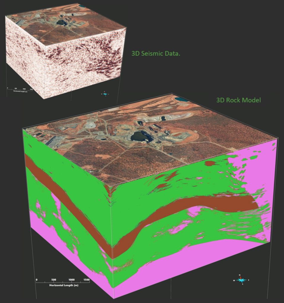
WHAT IS LITHO-MOD
LITHO-MOD maps the distribution of rock types and rock properties in 3D beyond the limits of existing measurements by integrating 1D drill hole data with 3D seismic data using Quantitative Interpretation (QI) techniques. A seismic dataset samples the earth with more detail than any other geophysical dataset.
WHY THIS IS IMPORTANT FOR EXPLORATION
Knowledge of the distribution of geological units is fundamental to the understanding of a mineral deposits. Some mineral deposits are emplaced within particular geological units (eg Sediment hosted copper deposits and magmatic nickel deposits).
Others are emplaced during structural deformation and may be precipitated out of hydrothermal fluids due to changes in chemistry or pressure due to rheological contrasts at lithological boundaries.
WHY THIS IS IMPORTANT FOR GEOTECHNICAL
Understanding the distribution of different geological units allows the optimisation of the placement of underground and open pit mine development, blasting design and production forecasting.
Case Studies
How LITHO-MOD helps our clients.
3D Rock Model from seismic enables cost-effective drilling and geotechnical insight for mine design.
“Another innovation is the 3D seismic survey carried out at the site last year… The resulting dataset is of a high quality and has been interpreted to create a structural model that has facilitated cost-effective planning of deep drill holes as well as providing important geotechnical and structural information.”
Michael Erickson, Senior Vice President – AngloGold Ashanti, Kalgoorlie Miner interview.
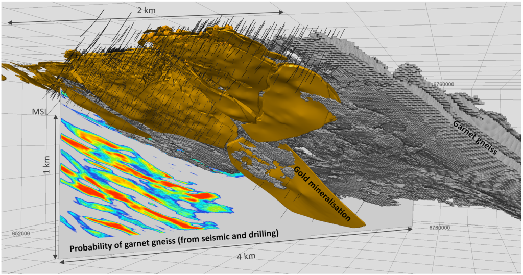
CHALLENGE
AngloGold Ashanti wanted to accelerate exploration down dip in a highly endowed region of the Fraser Range in Western Australia in a cost-effective manner. They also needed to understanding potential geotechnical risks in underground mine planning.
SOLUTION
HiSeis conducted several 2D and 3D seismic surveys covering a volume of ~ 55Km3. Advanced seismic attribute analysis was applied to illuminate structural framework and Quantitative Interpretation techniques were used to map lithologies in 3D.
RESULTS
The high quality seismic dataset was able to map the Garnett Gneiss host rock beyond drill hole data, enhancing drill targeting down dip. Key faults were also identified for geotechnical input into mine planning.
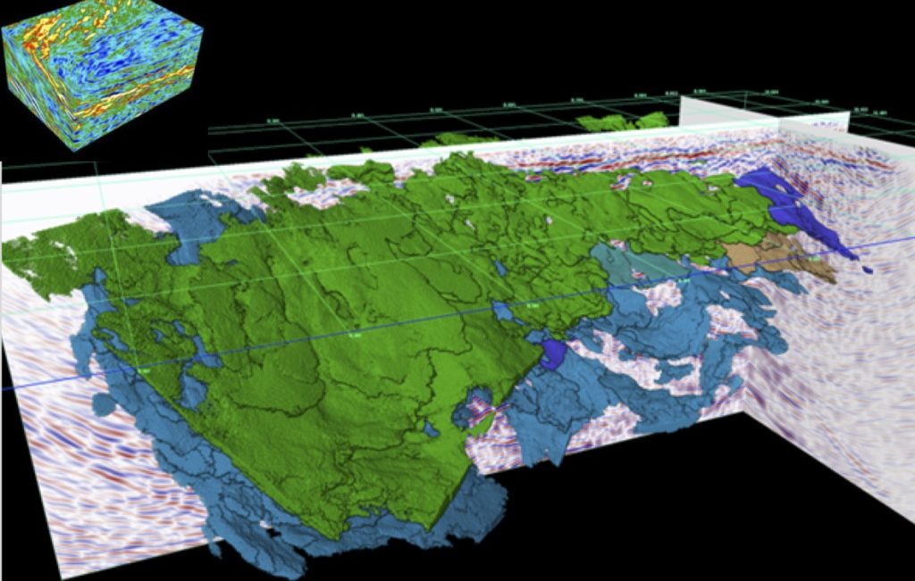
Finding blind ore bodies using 3D Seismic
Two of the key targeting criteria at St Ives are structure and lithography. 3D Seismic provided deeper insight into both through HiSeis proprietary workflows and joint inversion with drill hole data.
CHALLENGE
The St Ives Gold Field has produced in excess of 10.5M ounces from 60+ deposits over a broad 35km corridor in the Eastern Gold Fields. Significant resource potential remains below current workings but increasing costs with depth requires better geological definition for drill targeting.
SOLUTION
HiSeis were commissioned by Gold Fields to perform a 3D Seismic survey to investigate deeper into the subsurface and illuminate key components of the underlying mineral system that defines distribution of ore deposits. A 3D Rock Classification volume was created using joint inversion of lithology from drill hole data and P-Impedance from seismic data.
RESULTS
3D seismic effectively illuminated la roe scaIe geological structure several kilometers into the subsurface. Three main rock units were mapped across the entire 3D volume providing valuable insight into the local mineral system for input into drill targeting workflows.
Between, below & beyond
Mapping lithology beyond drilling.
We can’t predict your future
but we can help you see underground.